A. Sutherland – AncientPages.com – The ancient Roman fortification systems, known as limes, were not just a simple line of defense. They were a complex network of defensive structures, a testament to the advanced engineering and military tactics of the Romans.
This intricate system included forts, watchtowers, signal towers, palisades, stone and brick walls, legion and auxiliary camps (castra), reinforcement camps, fortified cities, and impressive fortresses.
This extensive array of fortifications served as a barrier, effectively safeguarding the Roman Empire’s borders and territories.
1. Petavonium

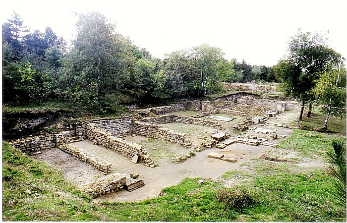
Praetorium or officers’ houses of the Flavian II Wing cavalry corps, built in the first century. Image credit: David Perez – CC BY 3.0

Archaeological excavation of the Roman ruins of Petavonium. Image credit: Majemico – CC BY-SA 3.0 ES Deed
The Roman fort of Petavonium was a legionary fortress (Zamora, Spain), founded to monitor the movements of the Astures peoples.
It was located between Astorga (Astúrica Augusta) and Braga (Bracara Augusta). The military compound had an extended 17 hectares and a detachment of 5,000 legionaries from the Legio X Gemina. These soldiers remained in Petavonium from 19 BC to 63 AD and had to prevent possible revolts, and to protect the transport of gold. Later, Nero moved the forces out of the peninsula, to the Danube limes (Panony).
The fort (existed during the 4th and 5th centuries) had an area with public baths, and a temple dedicated to Hercules, four watchtowers, and more. Remains of various buildings, crafts, cooking, food store were unearthed.
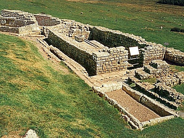
2. Novae

Novae – ruins of the military hospital (valetudinarium). Image credit:
Novae – legionary headquaters. Image credit: Kleo73 – CC BY-SA 3.0
Remains of the Roman legionary camp Novae are scattered close to the Danube port city of Svishtov, Bulgaria. Founded in 45 AD by order of Emperor Claudius, Novae fort was built on the ruins of an earlier Thracian settlement. The legionary fortress (castra legionis) covers an area of 18 hectares on a slope towards the river-bank. It was an important military center (legionary camp, fortress) and later civilian (city) located in the Roman province of Mesia Dolna (Moesia Inferior).
The Severan dynasty (AD 193 and 235) marked a period of significant prosperity for both Novae and the broader province. During this era, the city and the region experienced notable economic growth and development, reflecting the stability and favorable conditions that prevailed under the rule of the Severan emperors.
The city of Novae functioned as a strategic base for Roman military operations against Barbarian tribes, notably during Trajan’s Dacian Wars from 101 to 106 AD and the subsequent Balkan campaigns under Emperor Maurice. Furthermore, the legion stationed at Novae played a crucial role in constructing bridges across the Danube River, facilitating the movement of troops and supplies.
3. Segontium

The remains of the strongroom beneath the Principia. Image credit: Alan Fryer – CC BY-SA 2.0

Segontium Roman fort ( Wales ). Fundaments of the praetorium ( commander’s house ). Image credit: Wolfgang Sauber – CC BY-SA 3.0
An important Roman fortress perched on the northern coast of present-day Wales, in the city of Caernarfon, Gwynedd, is a site of profound historical significance. This fortification is the longest-maintained Roman fort within its borders. Julius Agricola, following the conquest of the Ordovices tribe, constructed Segontium in 77 or 78 AD. Its strategic location atop a hill overlooking the Menai Strait underscores the Romans’ military ability in perfect securing their territorial holdings.
Auxilia – specialized troops from the Roman provinces – supporting the main forces of the pedestrian legions (these units were mainly driving and archers) stationed in the fort.
It was probably planned to station a 500-strong infantry and cavalry division, some believed, the fort was to be manned by up to 1,000 infantry soldiers.
4. Isca Augusta (Isca Silurum)

Isca Augusta – Photograph of the military amphitheatre at Caerleon. Image credit: Greenshed – Public Domain

Prysg Field Barracks, Isca Augusta. Image credit: Pwimageglow – Public Domain
Isca Augusta (Isca Silurum), was a Roman legionary timber fortress (now under parts of the present-day Caerleon town, South Wales. Founded between 70 AD and 80 AD, the structure measured 1,600 by 1,350 feet (nearly 490 by 410 m), and included a substantial area of approximately 50 acres (21 hectares) within its fortified defenses.
It could easily accommodate a legion (five to six thousand soldiers). In fact, Isca Silurum could house up to 5,000 soldiers of the Legion II Augusta until at least 300 AD. Historical evidence suggests that the fortress was built by the soldiers of Legio II Augusta, who stationed in the fortress until the mid-fourth century.
5. Ribchester (Bremetennacum)

Image credit: – Immanuel Giel – Public Domain
Archaeological excavation work near the granaries at Ribchester, Lancashire. Image credit: – CC BY-SA 4.0
The fort (now only ruins) was located in Lancashire, England. It guarded the River Ribble’s crossing point. Built of a timber fort, constructed during the campaigns of Petillius Cerialis around AD 72/3. It was first stationed in Britain by Marcus Aurelius in 175. The fort was first built of a timber believed to have been constructed around AD 72/3, during the campaigns of Petillius Cerialis, a Roman general and administrator who served in Britain during Boudica‘s rebellion. Then, the structure was replaced by a stone fort in the 2nd century. For most of its existence the fort was garrisoned by Sarmatian auxiliaries (from the central parts of the Eurasian Steppe), first stationed in Britain by Marcus Aurelius in 175. Pottery evidence indicates that the fort was occupied for most of the 4th century until the end of the Roman period.
6. Binchester Roman Fort – Vinovia (AD 79)

Binchester Roman Fort – Image credit: John Phillips – CC BY-SA 2.0

Binchester Roman latrine (one of many distributed around the fort perimeter.) Image credit: University of Durham
It was located above the River Wear outside Bishop Auckland (Co Durham), guarded the main road between York, Hadrian’s Wall and Scotland. A military site and a vicus grew up at its gates. Now only traces of ramparts and a road are seen.
Binchester Roman Fort (Vinovia/Vinovium), County Durham – founded c.80 AD and for a time one of the largest (7 hectares) Roman military forts in Northern Britain. People continued to live there for centuries after Britain ended to be part of the Roman Empire.
7. Irgenhausen Castrum

Roman Fort in Irgenhausen, Switzerland. Image credit: Roland Zumbühl – CC BY-SA 3.0
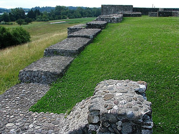
Image credit: Roland zh – CC BY-SA 3.0 DEED
It was a Roman square fort (60m – 197 ft) near Pfäffikersee Lake, Switzerland, with 4 corner towers and three additional ones. It is dated to era of Emperor Diocletian c. AD 294–295 or Valentinian II (364 to 375 AD.
The fort served as a strategic defense for safeguarding the traffic and supply routes leading to the Roman Rhine border. Among the probable responsibilities of the garrison stationed there were the monitoring of road traffic, temporary storage of provisions, facilitation of message relay, and the capability to obstruct the road in the event of barbarian incursions. A roadblock could be effectively managed with a modest contingent, as the lake encompassed the entire Irgenhausener Ried region during that period.
8. Hardknott Roman Fort (Mediobogdum)

Image credit: Rob Farrow – CC BY-SA 2.0

Image credit: Mick Knapton – CC BY-SA 3.0 DEED
Roman Sauna. This “Laconicum” forms part of the bathhouse which served the Roman Fort of Mediobogdum, now known as Hardknott Castle. This circular sauna was separate from the rest of the 546609 and was supplied with its heat from its own furnace via a flue system.
It had its location in Cumbria, England. Built between AD 120 and 138 and abandoned during Antonine’s advance into Scotland (the 2nd century). The fortress was114 m long outside, 105 m long inside – wall’s thickness c. 1.7 m with a moat. The square-shaped fort with rounded corners, has external length measuresing 114 m, while the internal length is 105 m.
The rampart wall is almost 1.7 m thick, and the ditches contribute to the overall width of the rampart. The low walls of the fort underwent restoration work in the past, with a slate course indicating the original height of the walls before their rebuilding.
9. Vindolanda (Chesterholm) Fort

Image credit: Chris Gunns – CC BY-SA 2.0

Image credit: Francis (Groningen, Netherlands) – CC BY 2.0
The ruins of this fort can be found in Northumberland. The fort served auxiliary troops at Chesterholm, just south of Hadrian’s Wall in northern England, near the modern border with Scotland. It had nine construction phases and was occupied from about 85 AD onwards. Later, it was integrated into the defenses supporting the famous Hadrian’s Wall. It is famous for finding the Vindolanda tablets, one of the most important finds of military and private correspondence (written on wooden tablets) found anywhere in the Empire.
10. Fortress “Sostra”
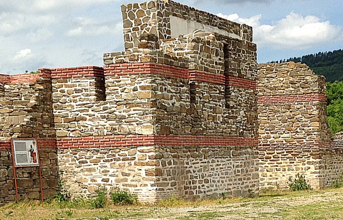
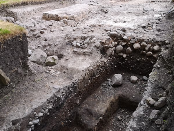
Later fort and foundation of original fort wall from 147. Image credit: ADRjdeadly – CC BY-SA 4.0

Image credit: Kamen Hadjiev – CC BY-SA 4.0
The ruins of Sostra – an ancient Roman fort and settlement are located near the village of Lomets, northern Bulgaria. The fortress was built c. 147 AD under the Emperor Antoninus Pius. Sostra was strategically situated along the major Roman road (the Via Traiana) linking ancient Philippopolis (today’s city of Plovdiv) and Diocletianopolis in the Roman province of Thrace with the Roman outposts – Ulpia Oescus (near today’s Gigen) and Novae (near today’s Shishtov) on the Limes Moesiae on the Danube. The road was vital in Trajan’s Dacian Wars against the Thracian tribes north of the Danube.
Sostra was targeted by the Goths in 249 and in 378, then, destroyed by the Huns at the end of the 5th century. Its remains have been excavated and partially restored. Archaeologists unearthed jewelry, silver coins, clay pots, a shrine of a Thracian god.
11. The Saxon Shore Fort

Image credit: Nilfanion – CC BY-SA 4.0
It contained several fortifications built during the 3rd century AD. Initially, the fort had to safeguard Roman Britain from the threat of seaborne incursions by marauding Saxon raiders, who traversed the North Sea. The fort also regulated maritime commerce of the region. The structures were strategically positioned at important coastal inlets and estuaries, and protected key Roman settlements in the area between the Wash in northern Norfolk, encircling the eastern and southern coasts of England, and further extended as far as Portchester Castle in Hampshire.
12. Chesters Roman Fort (Cilurnum)

Commandant’s house (praetorium, foreground) and headquarters (principia, background) at Cilurnum Roman Fort (Chesters) near Chollerford in Northumberland. Image credit: mattbuck – CC BY-SA 4.

Ruins of soldiers’ barracks at Chesters Roman Fort, along Hadrian’s Wall. There is a gutter visible, which was in the courtyard between the barracks. Image credit: Public Domain
During time of the Roman Empire, Cilurnum, along Hadrian’s Wall, was one of the Roman Empire’s most northern outposts and the most complete Roman cavalry fort in Britain. It has well-preserved baths, a steam room, and officers’ quarters. Emperor Hadrian encouraged the worship of the goddess Disciplina as witnessed by an old dedicatory inscription on a stone altar (is still in the fort) and discovered in 1978.
The fort guarded Chesters Bridge over the River North Tyne, carrying the Military Way behind the wall across the River North Tyne. Massive substructures of this bridge across the river from the fort still survive.
13. Burgh Castle, Gariannonum (Gariannum)

The well-preserved southern walls of the Burgh Castle. Image credit: Pahazzard – CC BY-SA 3.0

Gariannonum Burgh Castle, a round tower at the east wall. Image credit: Pahazzard – CC BY-SA 3.0
It represented one of nine Forts of the Saxon Shore, built in Norfolk, England, in the 3rd century AD to hold troops and defend against Saxon raids. It is one of the most impressive Roman buildings to survive anywhere in Britain. The fort is almost rectangular, measuring (internally) c. 205 m (673 ft) by 100 m (330 ft). Its walls on the north, east, and much of the south side are largely intact, standing at a height of approximately 4.6 m (15 ft) and measuring up to 3 m (9.8 ft) thick at the base.
It has six solid bastions, symmetrically, placed two on the south wall, one each at the north-east and south-east angles, one slipped from the position on the north wall, and one below the south wall where it has fallen. Coin and pottery found at the site date from the mid-3rd century AD to 5th century AD.
14. Portus Adurni Roman Fort

Image credit: scale speeder – CC BY 2.0

Image credit: Philip Halling – CC BY-SA 2.0
The fort – once important in the Roman province of Britannia- is now situated at the north end of Portsmouth Harbour, Portsmouth, England. It was built in the 3rd century CE. The square-shaped fort, with 6 m high and 200 m long external, 3 m thick walls, is still well-preserved. Portus Adurni has towers all along the walls. and was part of the so-called “Saxon Bank.”
Its goals were to secure and defend the fort and control the trade and transport of goods. Square-shaped forts became widely used during the 3rd century, being highly practical and defensible.
15. Aquis Querquennis Fort

Aquis Querquennis in the province of Ourense in Galicia, Spain. Image credit: Jdejosito – CC BY-SA 4.0

Aquis Querquennis in the province of Ourense in Galicia, Spain – Main entrance to the Roman site enclosure. Image credit: Adrián Estévez (Estevoaei) – CC BY-SA 3.0
Aquis Querquennis is located in Ourense Province, Galicia, accommodated 500 persons. It covered an area of 25,000 sq.m and was built in 69-79 AD and left in 120 AD. The mansion had a place for travelers and stables for cavalry horses. There’s still the oven for baking bread and a circular well. The fort housed Roman legions for the purpose of either colonizing or building the famous “Via Nova” road (or Via XVIII), which linked the cities of Bracara Augusta (modern name: Braga) and Asturica Augusta (today: Astorga), with a length of about 210 roman miles (about 330 kilometers).
16. Housesteads Roman Fort

The northern granary at Vercovicium, looking east. The pillars supported a raised floor to keep food dry and free from vermin. They are not part of a hypocaust. Uploaded by Fryslan0109 – CC BY-SA 3.0
The latrines at Housesteads on Hadrian’s Wall, hygienically placed at the lowest corner of the fort. The water tank at left still has original lead sealing between its slabs. Image credit: Mediatus (H.J.)/Wikimedia Commons/CC-BY-SA-3.0 and GFDL
Housesteads, situated in Northumberland, England, is a remarkable archaeological site that preserves the remnants of an auxiliary fort constructed along the renowned Hadrian’s Wall. Erected in stone circa 124 AD, this fortification underwent various name iterations, including Vercovicium, Borcovicus, Borcovicium, and Velurtion. Notably, the fort’s wall stood at an impressive height of 4.2 meters during its prime.
Among the Roman forts that once dotted Hadrian’s Wall, Housesteads stands out as the most meticulously preserved, offering a unique glimpse into the architectural and functional elements of a typical Roman fortification. There are various structures that once served vital purposes within the fort’s confines, including barracks, the headquarters block, the commander’s residence, granaries, a hospital, latrines, and an intact circuit of defensive walls.
This archaeological treasure trove including including altars, jewellery, tools and weapons, provides an unparalleled opportunity to look into the intricate details of Roman military life.
Surrounding the Fort itself is a fascinating Roman military landscape including the civilian settlement, the temple area, parade ground, cultivated fields and Roman roads.
17. Auxiliary Fort of Wroxeter (Viroconium)

The ruins of Viroconium’s public baths at Wroxeter. Image credit: Alastair Rae – CC BY-SA 2.0

Modern pilae stacks are replicas of the originals, which were taken by souvenir hunters during the late 19th century. Author: Francis Bedford (1815–1894) Victor von Gegerfelt collection, Region- och Stadsarkivet Göteborg.
The fort was timber-built, probably the 1st permanent structure built by the Romans in this area. It accomodated 500 cavalrymen and covered an occupation area of c. 1.9 ha.
The Auxiliary Fort of Wroxeter (Viroconium) – located in Shropshire, England c. AD 47 – was strategically positioned on level terrain elevated above the eastern bank of the River Severn, about 2,000 feet to the south of the southern corner of the Roman city’s defensive fortifications. This strategic placement underscores the military significance and defensive capabilities of the fort in relation to the adjacent Roman settlement.
The dimensions of the fort extend c. 515 feet from east to west and 470 feet from north to south (157 m by 143 m), encompassing an area slightly exceeding 5½ acres (2.25 hectares).
18. Anderida (

Inner Keep, Pevensey Castle. Image credit: Simon Carey – CC BY-SA 2.0

Bastion, Outer Walls – once part of the original Roman fort ‘Anderida’, Image credit: Simon Carey – CC BY-SA 2.0
It was a Saxon Shore Fort located in eastern Pevensey, East Sussex (once the Roman province of Britannia.) The structure was later converted into a medieval castle – Pevensey Castle. The ruins of this ancient fort are situated adjoining the western outermost of the village of Pevensey in East Sussex, England. Historical evidence suggests that its construction likely dates back to about AD 290, and it was subsequently subjected to pillaging in AD 471 (491).
The site was important throughout the ancient era. Despite the passage of time, the original Roman stonework remains visible, although the precise motivations behind its construction remain unclear. Following the end of the Roman occupation, Anderitum fell into a state of disrepair. It was later reoccupied in 1066 by the Norman invaders.
19. Portus Lemanis

Archaeological excavations of the east gate of Portus Lemanis in 1976. Excavations of the site were carried out between 1976 and 1978. Portus Lemanis is also known as Stutfall Castle. Image credit:
This Saxon Shore-era fort dates back to the late 270s AD. It did not serve as a landing site for the Roman invasion of 43 AD but rather functioned as a port for the newly established Roman Channel Fleet, situated along the inhospitable and treacherous coastline opposite the Isle of Wight, similar to the port of Chichester in Sussex. The remains of a bath and a possible headquarters building (Principia) are in poor condition. The main rampart, once a formidable structure measuring ca.3.9 meters wide, is now in ruins between 6 and 8 m in height.
Originally, the fort may have had around 14 towers and several defensive outposts. Its shape is believed to have been an irregular pentagon, encompassing an area of ca.3.4 hectares.
Aesica Roman Fort Fort on Hadrian’s Wall. Image credit: mauldy – CC BY-SA 2.0
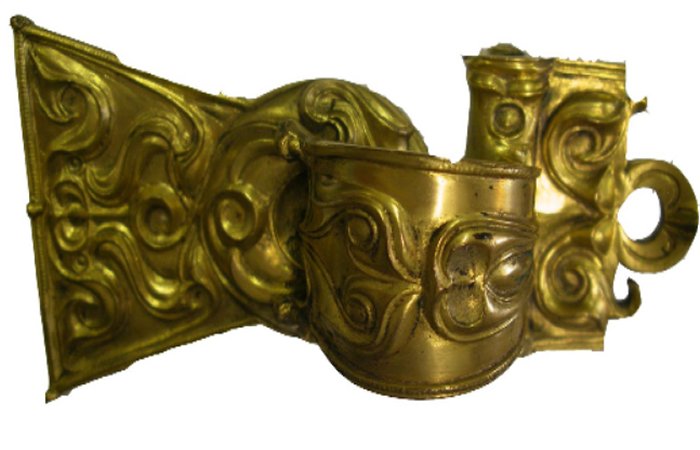
Copper alloy replica of the Aesica brooch. The gilt original found in the fort of Aesica on Hadrian’s Wall (Great Chester, Northumberland) and now in the Black Gate Museum, Newcastle-on-Tyne. Given by Parker Brewis, Esq., 1991. The finest example of the Romano-Celtic decorative art that flourished in Northen Britain (territory of the Brigantes) in the earlier part of the 2nd Century AD. Image source.
Its modern name is Great Chesters. It was a Roman oblong fort, one and a half miles north of Haltwhistle, Northumberland, England. It was the ninth fort along Hadrian’s Wall that deviates from the typical placement of fortifications along this ancient Roman defensive structure. Unlike its counterparts, Aesica Fortis is located to the south of the Wall itself, strategically positioned to safeguard the Caw Gap, where the Haltwhistle Burn River traverses the Wall.
The original design of Aesica incorporated three main gates, each featuring double portals, complemented by towers at every corner. However, at a certain, important moment in its history, the western gate of the fort underwent a significant alteration, resulting in its complete blockage.
The archaeological excavations conducted in the year 1894 yielded a remarkable trove of invaluable artifacts from the ancient site of Aesica, dated to c. 70 AD. Among them, there was a gilded bronze brooch, considered a masterpiece of Celtic artistry a bronze ring adorned with a Gnostic gemstone, and an exquisitely enameled brooch meticulously crafted in the form of a hare.
Written by – A. Sutherland – AncientPages.com Senior Staff Writer
Copyright © AncientPages.com All rights reserved. This material may not be published, broadcast, rewritten or redistributed in whole or part without thexpress written permission of AncientPages.com