Jan Bartek – AncientPages.com – Scientists have identified approximately 630,000 ancient charcoal kilns in Poland, highlighting the significant role these structures played in pre-industrial societies. While charcoal is commonly linked to modern recreational grilling, it was once as vital to early economies as oil or nuclear energy is today.
Charcoal kilns and furnaces were fundamental to technological progress, providing essential energy for metallurgy, craftsmanship, and heating. Their construction techniques reveal much about the resourcefulness of past civilizations.

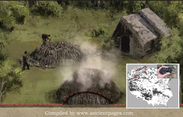
Construction of a charcoal kiln. Drawing by Tomasz Ryger. Słowiński, M, et al
Producing materials like glass for windows or iron for tools required extremely high temperatures—between 500 and 800 degrees Celsius—which charcoal could reliably provide in smelters and bloomeries. Beyond fuel, the process of wood carbonization yielded valuable byproducts: resin used for sealing boats, tar for treating leather, and potash from ash—a key ingredient in gunpowder production. These discoveries underscore the central role of charcoal technology in shaping early human innovation.
Many ancient charcoal kilns have only recently been discovered because their traces were hidden by forest regrowth. Forests in the European lowlands shaped human life, providing resources like shelter and building materials.

Researchers located 630,000 traces of charcoal hearths—structures used for burning charcoal—using lidar data. Source: Mapping and spatial distribution of relict charcoal hearths across Poland Earth System Science Data 2026, M. Słowiński et al.
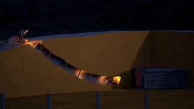
Charcoal production involved stacking large piles of wood, covering them to cut off oxygen, and burning them for 10–20 days. Each pile used up to 250 cubic meters of wood—about half a hectare of forest—before makers moved to new sites with available wood.
Historians missed these activities because charcoal makers frequently relocated, leaving little lasting evidence. Old maps showed stable forest boundaries, but pollen analyses revealed significant changes within these forests over time. Charcoal makers exploited specific areas without clearing forests for farmland; after production, forests regrew and concealed the remains of their work.
Although the charcoal piles are difficult to see with the naked eye today, coal burning permanently altered the soil, creating so-called anthropogenic soil. Prolonged high temperatures sterilize the soil and alter its pH. Even after 100 years, significantly fewer bacteria and fungi remain in the charcoal pile, and heavy metal concentrations, such as cadmium, remain elevated.
The key to determining the scale of charcoal production in Poland was airborne laser scanning (LiDAR) imagery, which reveals the land surface without vegetation. The charcoal pit is a distinctive, slightly sunken circle. Scholarship recipient Krzysztof Szewczyk spent two years analyzing maps nationwide, identifying more than 630,000 such features.

Mapping and spatial distribution of relict charcoal hearths across Poland Earth System Science Data 2026, M. Słowiński et al.
These sites were primarily discovered in regions currently covered by forest. It is likely that many additional sites once existed, but evidence of them has been lost due to agricultural practices and urban development. Nevertheless, the legacy of tar burners and builders endures through local place names. Onomastic research—the study of proper names—indicates that charcoal burning activities are reflected in numerous place names dating back to before the 17th century, including Smolary, Budy, Kuźnica, Szklary, and Poręba.
Professor Michal Słowiński’s team from the Institute of Geography and Spatial Organization of the Polish Academy of Sciences conducted the research.
Professor Słowiński emphasized that charcoal piles should be regarded as archaeological monuments and industrial heritage. He also announced the release of an open database where anyone can check the presence of these “ephemeral reactors” in their area.
See also: More Archaeology News
The researcher concluded that an interdisciplinary team of experts worked on the topic, including paleoecologists, historians, linguists, soil scientists, foresters, cartographers, GIS specialists, dendrologists, microbiologists, climatologists, phytosociologists, hydrologists, and geomorphologists.
Thanks to this collaboration, the team was able not only to map charcoal piles but also to understand, among other things, why they were created, how they functioned, and what impact they had on the natural environment and the scale of human interaction with the landscape.
Source: Science in Poland
Written by Jan Bartek – AncientPages.com Staff Writer