11 Reconstructions Of Ancient Cities, Monuments And Sacred Sites

A. Sutherland – AncientPages.com – Anyone interested in ancient history has undoubtedly seen a number of prehistoric ruins that were once part of magnificent ancient monuments, cities and sacred sites.
Today, these ruins are all that is left of buildings raised by powerful and great ancient civilizations that no longer exist. Have you ever wondered what these ancient places looked like when they existed? In this top list we examine 10 magnificent, ancient reconstructions of monuments, cities and other stunning ancient and sacred places.
1. Ancient City Of Knossos – Island Of Crete
Image credit: Mmoyaq – CC BY-SA 3.0
Knossos, “renowned as a glorious site of the Greek Bronze Age, the leader of Crete and the seat of the palace of the mythical King Minos and the home of the enigmatic labyrinth,” was the prosperous epicenter of Minoan culture.
Recent fieldwork at the ancient city of Knossos on the Greek island of Crete revealed that during the early Iron Age (1100 to 600 BC), the city was rich in imports and was nearly three times larger than what was believed from earlier excavations.
The discovery suggests that not only did this spectacular site in the Greek Bronze Age (between 3500 and 1100 BC) recover from the collapse of the socio-political system around 1200 BC, but also rapidly grew and thrived as a cosmopolitan hub of the Aegean and Mediterranean regions.
2. Rathcroghan Mound – Ireland
Conjectural reconstruction of Rathcroghan Mound in the late Iron Age, by JG O’Donoghue. Image courtesy of Rathcroghan Visitor Centre – CC0
The magnificent and enigmatic Rathcroghan Mound in Ireland is on the UNESCO World Heritage list. At this mysterious place, ancient kings were inaugurated at the ceremonial heart of Rathcroghan. The mound in the fort of Rathbrennan is also the place where Patrick is said to have met the king of Connacht and Cailte, the nephew of Fionn mac Cumaill.
This ancient site witnessed the rise and fall of great tribes, wealthy chieftains and dynastic families. Some of these went on to rule the whole island as high kings, ensuring the continuing legacy of this unique complex well into the modern era.
3. The Ziggurat Of Etemenanki In Babylon
Left: Model of Etemenanki. Pergamonmuseum (Berlin). Image credit: O.Mustafin – CC0 1.0. Right: The Babylonian tower Etemenanki, complements. Image credit: Robert Koldewey (Schriftleiter: Friedrich Schultze und Richard Bergius)
Etemenanki was the Sumerian name of a ziggurat dedicated to Marduk in the city of Babylon. The city of Babylon had been destroyed in 689 BCE by Sennacherib, who claims to have destroyed the Etemenanki. The city was restored by Nabopolassar and his son Nebuchadnezzar II. It took 88 years to rebuild the city; its central feature was the temple of Marduk (Esagila), with which the Etemenanki ziggurat was associated. The ziggurat was rebuilt by Nebuchadnezzar II. The seven stories of the ziggurat reached a height of 91 meters, according to a tablet from Uruk and contained a temple shrine at the top.
4. Palace Of Sargon, Iraq
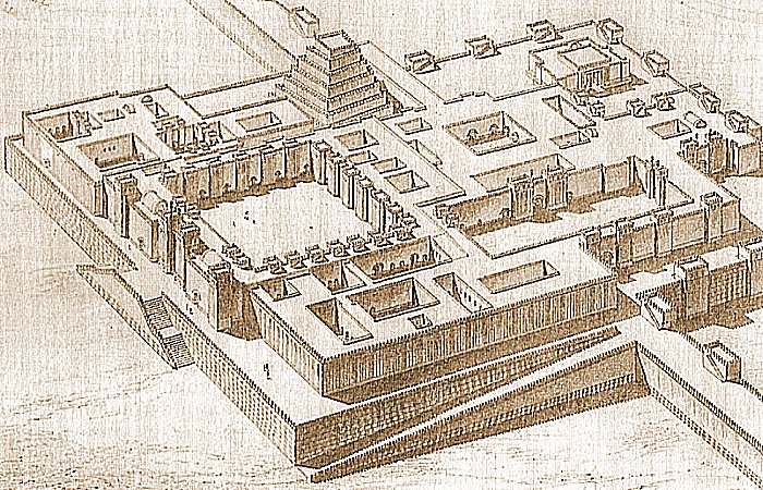
Palace of Sargon II in Dur-Sharrukin (reconstruction). Charles Chipiez/scan by Kuchumov Andrey – Public Domain
King Sargon II (721-705 B.C.) had a beautiful palace in Khorsabad, Iraq. Khorsabad takes its name from a modern Iraqi village that stands on the ruins of an ancient city called Dur-Sharrukin. Dur-Sharrukin (“Fort Sargon”) was constructed as a new capital city by the Assyrian king Sargon II shortly after he came to the throne in 721 B.C.
The city had not been completed when Sargon died in 705 B.C. His son and successor, Sennacherib, moved the capital to the old established city of Nineveh, about 15 miles to the south, and Dur-Sharrukin appears to have been largely abandoned. Archaeological excavations reveal Sargon’s palace had been richly decorated with relief-carved stone slabs. Many of these, including the fragments of a complete human-headed winged bull once guarded an entrance to the throne room.
5. Ziggurat Ur In Ancient Mesopotamia
Computer reconstruction of the Zugurat of Ur-Nammu, currently located on the outskirts of Nasiriyah and built at the beginning of the 21st century BCE.
Image credit: wikiwikiyarou – Public Domain
The ziggurat is the most distinctive architectural invention of the Ancient Near East. Like an ancient Egyptian pyramid, an ancient Near Eastern ziggurat has four sides and rises up to the realm of the gods. One of the largest and best-preserved ziggurats of Mesopotamia is the great Ziggurat at Ur. This artist rendering depicts when Babylon was a city-state of ancient Mesopotamia.
6. Colchester (Camulodunum)
Left: A 3D model reconstruction of what Camulodunum looked like during Roman times. Credit: Joseph Chittenden; Right: The model also shows the attack by Boudica and her 120,000 followers. Credit: : Joseph Chittenden
Colchester (Celtic name: Camulodunum – from the Celtic god of war), is the city in the Colchester district of Essex, England. Considered to be the oldest city in Britain, founded by the Romans (mentioned by Pliny the Elder in 77 AD). From the year 49, when the Romans advanced north, the city was known by the name of Colonia Claudia Victricensis, to commemorate Claudius’ victory over Britain (the title victrix may not have been awarded to the retired Roman soldiers, until it became apparent what a huge role he had played in suppressing the Queen Boudica (Colchester) uprising in 61 AD. (Camulodunum was a focal point of the Boudican revolt.)
The site included the emperor’s temple, theatre and senate house, but all these structures were completely destroyed by Boudica’s forces. After the destruction of the city, the administration and the main provincial government were most likely moved to London, but it is possible that the emperor’s temple itself was still in use.
The ancient history of Colchester is rather well-documented, but what did the town look like during Roman times? Concept designer Joseph Chittenden decided to find out and the result of his research is an astounding 3D model he created after having consulted with the Colchester Archaeological Trust.
7. Ancient Egyptian Capital Tell El-Amarna
The Small Aten Temple. This view is roughly easterly in direction and shows the Small Aten Temple which was close to the Pharaoh’s quarters on the left. Credits: Paul Docherty Principal Lecturer in 3D CG Teesside University
The layout of Tell el-Amarna, ancient Egypt’s capital during the reign of pharaoh Akhenaten (1353B.C–1336B.C), has been revealed through remote sensing techniques. Experts have created a detailed layout of the ancient city including its main streets, sections used for burial, ramps and transportation paths from the mines to the harbor.
The city was abandoned and deliberately ignored by followers of God Amun shortly after Akhenaten’s death.
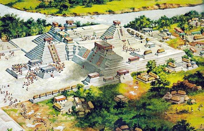
8. Rosalila – Temple Of The Early Classic Copan
Image credit: Latin American Studies (Fair use).
Copán is a locale in western Honduras, in the Copán Department, near to the Guatemalan border.
The ruins of the Copan is one of the most important sites of the Mayan civilization. This is the site of a major Maya kingdom of the Classic era (5th – 9th Centuries).
Rosalila is the temple of the early classic period. It is the most completely preserved example of the art and architecture of this period discovered to date.
The facades of the temple are elaborately decorated with complex religious messages. The themes are cosmological, and emphasize the Sun God, K’inich Ahau – divine patron for Maya kings, and the spiritual namesake of the founder of the dynasty, K’inich Yax K’uk Mo’.
The temple is located over a three-meter tall terraced pyramid, named “Azul.” There are seven steps on the principal stairway and the fifth step has a hieroglyphic dedication date: February 21, 571 A.D. This date is close to the end of the reign of Moon Jaguar, the tenth ruler of Copan.
9. Herod’s Temple
Left: The Second Jewish Temple. Model in the Israel Museum. Image credit: – CC BY 3.0; Right: Herod’s Temple (adjacent to the Shrine of the Book) as imagined in the Holyland Model of Jerusalem; east at the bottom. Image credit: – Public Domain
In the eighteenth year (20-19 B.C.) of his reign Herod rebuilt the Temple on a more magnificent scale. The Temple proper as reconstructed by Herod was of the same dimensions as that of Solomon, viz.: 60 cubits long, 20 cubits wide, and 40 cubits high. Around the Temple area were double colonnades. There were eight gates leading into the temple. In the western wall was the main gate named the Gate of Coponius after the first procurator; it was decorated with the golden eagle as a sign that the Temple had been placed under the protection of Rome.
Anyone was allowed to enter the outer area, which was therefore called the Court of the Gentiles.
10. Ancient City Of Babylon
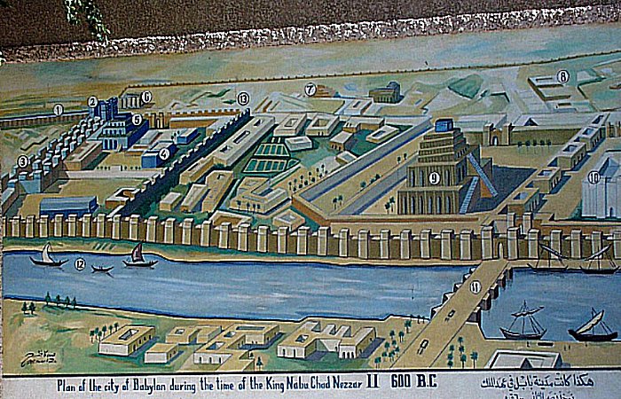
Plan of Babylon. Image credit: Radomil – CC BY-SA 3.0
Babylon was a city-state of ancient Mesopotamia, located on the lower Euphrates river in southern Mesopotamia, within modern-day Hillah, Iraq, about 85 km south of modern day Baghdad. It was the main cultural and political centre of the Akkadian-speaking region of Babylonia. Its rulers establishing two important empires in antiquity, the 19th–16th century BC Old Babylonian Empire, and the 7th–6th century BC Neo-Babylonian Empire.
Babylon was also used as a regional capital of other empires, such as the Achaemenid Empire, and one of the most important urban centres of the ancient Near East, until its decline during the Hellenistic period. Nearby ancient sites are Kish, Borsippa, Dilbat, and Kutha.
The remains of ancient Babylon are found in present-day Al Hillah, Babil Province, Iraq, about 85 kilometers (55 mi) south of Baghdad.
11. Sacred Precinct, Tenochtitlan
Left: Model of the Aztec City of Tenochtitlan at the National Museum of Anthropology in Mexico City. Image credit: Thelmadatter – Public Domain; Right: Model of sacred precint in the Museum of Anthropology. Image credit: s shepherd – CC BY 2.0
This is a a model reconstruction of the sacred precinct of Tenochtitlan, the Aztec capital on Lake Texcoco. The city was founded in 1345 CE and fell to the Spanish forces led by Cortés in 1521 CE. The sacred complex was dominated by the central pyramid known as the Temple Mayor, dedicated to the gods Tlaloc and Huitzilopochtli. It was the most important sacral building of the Aztecs, built in stages in the fourteenth and fifteenth centuries.
Located in the center of the Aztec capital of Tenochtitlán (its ruins are still in Mexico City), it was shaped like a step pyramid with two temples at the top. These temples, rising about 60 m above the level of the square at the foot of the pyramid. The Spaniards, after conquering the city in 1521, almost completely destroyed it as a symbol of pagan worship.
Written by – A. Sutherland – AncientPages.com Senior Staff Writer
Copyright © AncientPages.com All rights reserved. This material may not be published, broadcast, rewritten or redistributed in whole or part without thexpress written permission of AncientPages.com
Expand for references


